Waterlogging was little previous to the year 2000, but it has now become a major concern for local administration.
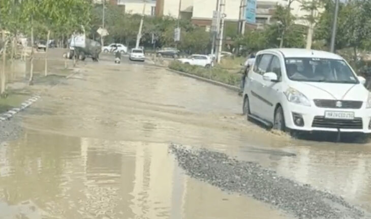
New Delhi : As the monsoon season approaches, Gurugram is poised to be submerged once more due to urban flooding, which is the consequence of uncontrolled massive urbanisation and a poorly executed plan to deal with waterlogging in the city and has made the people’s lives miserable during the season.
However, before 2000, the city did not face such a massive water logging problem, but with the expansion of the city through several mega projects while degrading several wetlands, a water logging problem grew up, turning the city’s roads, among the national highways, into a kind of canal.
While the city’s topography plays a major role, it contributes only around 30 percent to the waterlogging problem, said sources within the Gurugram Metropolitan Development Authority (GMDA). The bigger reason for water stagnation in the city is the high level of concretization.
In the 1950s, Gurugram was replete with water bodies that merrily captured both rainwater and water flowing downhill from the Aravallis slopes. As per a first-of-its-kind study done by the GMDA, the district had some 644 small and large water bodies. Out of the 644 water bodies, 153 were found to be vanished beyond recovery; another 53 bodies face a severe threat due to intentional landfilling, garbage and construction waste dumping, and encroachment; 132 water bodies face contamination due to the discharge of industrial affluent and wastewater; and the remaining 44 cannot be called water bodies as they experience only seasonal waterlogging.
Officials associated with the irrigation department said there were around 100 check dams built in the city to control the excess water flow, and that could address the problem of waterlogging due to the topological slope of the terrain. The Ghata, Jharsa, Wazirabad, and Chakkarpur are among the prominent bunds. “During the heavy downpour, the water collected in the catchment areas would control the flow of the water and ensure that excess water would not flow to lower-lying areas.
However, over the years, these catchment areas have vanished due to encroachment; shockingly, Ghata Lake, which is a seasonal water body, covered almost 370 acres until the early 2000s. The natural lake could hold some 50 feet of water until a few years ago. But unfortunately, it has been converted into a dumping ground. This is even more shocking since the Ghata Lake bed serves as a floodplain for storm water drains, especially those that enter Gurugram from Delhi, which aid the drainage around the city, especially during the monsoon. However, with the lake shrinking to less than 50 acres and poor maintenance of the drain, flooding is almost inevitable.
But with increased urbanisation and road construction, these bunds (dams) seem to have disappeared over time, resulting in flooding of the Golf Course Road and its neighbouring areas. GMDA states that there were at least 118 bundhs in the Gurugram–Faridabad area. But much information about them has ceased to exist over time. “These small channels are helpful because they break the flow of water into smaller rivulets. Traditionally, they were also used to irrigate agricultural fields and recharge groundwater levels, officials added.
But with the urbanisation of the city, it has been concretized right from the roads to drains and from public space to playgrounds. For most of the people living in urban areas, the solution to most problems lies in more construction, which means using building materials such as bitumen, steel, and cement. In most cases, it aggravates the problem instead of solving it. Consequently, water stays on impermeable surfaces, and with encroached and blocked drains, it remains stagnant for hours and days in the city. Waterlogging was not an issue in Gurugram until this millennium. The city had enough porous spaces for water to seep through. Hence, the city needs to have permeable spaces, which can be easily achieved by turfing, using interlocking tiles, etc.
As per the 2031 Master Plan for Gurugram Manesar Urban Complex, over 60 percent of the city’s area will be concretized. As it is, Gurugram’s green cover is extremely low, at less than 5 square metres per person.
“Researchers have established the extent of concretization by comparing the spatial maps of the city over the years and contrasting them with the ground situation,” said an official of the GMDA. Lack of planning and enforcement of laws has resulted in a significant narrowing of waterways. “Floodplains had been consumed by illegal developments, further leading to flooding in the city. Encroachment of floodplains, obstruction of sewer pipes, manholes, dumped construction material, and solid waste have blocked the system,” he added.
Moreover, the official said the departments have initiated the steps to harvest the rainwater as due to the heavy spell of rain, around 50 to 60 percent of the water will percolate as the city has soil composed of both sand and clay. Due to the non-optimal water harvesting system, around 80 percent goes to the Najafgarh drain, which leads to another step for waterlogging.
It’s not all about urbanisation; global warming has also played a significant role in aggravating the problem of waterlogging in Gurugram. “The city normally receives maximum rainfall from June to September, with an average annual rainfall of 795.4 mm and August being the wettest month. However, in 2010, the city experienced around 157 mm of rainfall in 29 days, which somehow increased to 229.4 mm in 2020 in 26 days. The total annual rains received in 2010 were 526 mm in 89 days, which goes up to 651 mm in 126 days in 2020,” the official said.
“Further, in 2019, the annual rainfall intensity jumped to 803.9 mm.” “That year, the city saw one of the worst floods in the region, which affected lives and property and led the city to come to a standstill,” he added.
Over time, a cemented drainage system has almost completely taken over the route of the natural course of drains, which has also blocked the natural course of water. Emerging residential blocks near the Dwarka motorway, new sectors, and several areas of older Gurugram do not have drainage infrastructure. Moreover, some concreted drainage lines are blocked due to construction debris or encroachment; therefore, they are lacking in capacity to carry heavy surface runoff during the monsoons. And if the drainage system is choked, the road will be submerged in rainwater. The drainage infrastructure has not been designed to withstand a high intensity of rainfall,” said an expert in urban transport systems design.
At present, three master stormwater drains—legs 1, 2, and 3 (the Badshahpur drain)—are currently used to dispose of the rainwater that falls in Gurugram. Badshahpur Drain makes up more than 60% of the drainage system and carries runoff from more than 24,000 hectares of land. These master drains catch rainwater and direct it into Delhi’s Najafgarh drain.
“What makes things worse is that city roads have been planned along natural water channels,” experts said. It is most likely because building roadways alongside the waterways was simpler. Additionally, many city roads flood since the water doesn’t alter its path and keeps flowing in the same direction. In addition to causing more water to stagnate, increased concretization also eliminates opportunities for groundwater recharge.
Things have gotten worse as a result of inadequate drainage infrastructure. The entire city is served by seven main drains. The second drain, bringing water from DLF 1, 2, and 3, Sushant Lok-1, MG Road, and other nearby locations, enters the Najafgarh drain through Iffcco Chowk, as opposed to the first drain along Ambience Mall, which empties directly into the Najafgarh drain.
On the other hand, the Badshapur drain near Khandsa is where the remaining five drains open, making the intersection extremely prone to flooding. “The water from major parts of the city comes down to Khandsa, which becomes a problem when there is very heavy water flow,” said the official.
The drain has a 2,300-cusec total capacity between Ghata and Khandsa, but it substantially decreases to 500 cusec at Khandsa, resulting in waterlogging during Gurujam. The drain has now been enlarged by HSVP to hold 1,400 cusec, and work to add the remaining 1,900 cusec is in progress.
Although its capacity is only 1,150 cubic feet per second, the same drain at Vatika Chowk receives almost 1,900 cubic feet per second of water. Clogged drains, a delay in their cleaning, and a lack of cooperation among numerous government organisations, including NHAI, GMDA, MCG, and the district administration, have all contributed to the city’s waterlogging condition getting worse.